

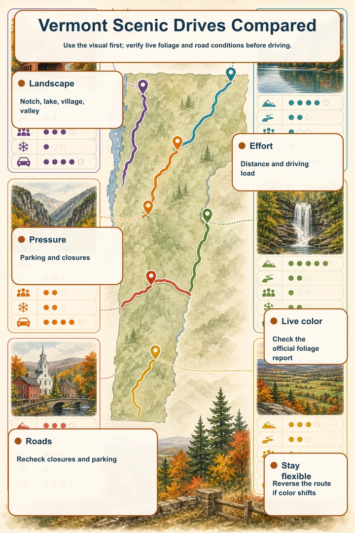
Use the visual first; verify live foliage and road conditions before driving.
- LandscapeNotch, lake, village, valley
- EffortDistance and driving load
- PressureParking and closures
- Live colorCheck the official foliage report
- RoadsRecheck closures and parking
- Stay flexibleReverse the route if color shifts
Use the map to build a foliage drive
Start with the mapped stops, then choose a corridor that matches the kind of scenery you want. Route 100 links a long sequence of mountain landscapes, but its length makes a focused segment the more practical plan. Moss Glen Falls is a clear anchor for a Route 100 outing, while Smugglers’ Notch gives Route 108 a more concentrated mountain setting.
The map also separates drives that look similar on paper but feel different on the ground. Route 17 reaches the Appalachian Gap by a steep, winding road; Route 5A frames Lake Willoughby with water and mountains; US 4 combines Quechee Gorge with Woodstock’s walkable historic scenery; and Champlain Valley back roads lead toward Mount Philo. Select stops by access, visit length, and crowd level rather than treating every marker as equally easy.
Treat color windows as planning ranges
The supplied historical planning windows place Lake Willoughby and the higher Route 108 and Route 17 terrain in a generally earlier northern or mountain planning range than Woodstock and Quechee. Those ranges are not a 2026 forecast. Exact 2026 color timing remains TBA until a live official foliage report confirms current conditions.
Before leaving, check Vermont’s current foliage information along with road status and any site-specific notices. Live conditions override static planning ranges, especially where a road is seasonal or a facility has operating-season rules.
Which Vermont drive fits your day?
Route 100 suits travelers who want a classic mountain-road day with a roadside waterfall as a defined stop. Because the route is long, choose a segment and place Moss Glen Falls on the map rather than promising to cover the whole highway. This is a flexible option for travelers who prefer scenic pull-offs and a short walk over a single summit viewpoint.
Route 108 through Smugglers’ Notch is better for a concentrated notch experience, boulders, and a short walk, but it demands more attention to seasonal access and vehicle size. Route 17 and Appalachian Gap suit drivers comfortable with steep, winding terrain and a brief overlook stop. Neither corridor should be approached as a casual place to stop on blind curves.
US 4 combines the high-visibility draw of Quechee Gorge with Woodstock’s covered bridge and village setting. It suits travelers who want scenery plus walkable cultural stops, though the most popular locations bring higher crowd pressure. Route 5A and Lake Willoughby offer a quieter-feeling lake-and-mountain objective, while Champlain Valley roads and Mount Philo provide a summit-oriented alternative with either a drive-up approach or a hike when the summit road is unavailable.
Plan around legal parking and seasonal access
A scenic road is not automatically a stopping place. Use signed pull-offs, designated parking, visitor areas, and town parking; never stop in a travel lane or on a blind curve. This matters at Moss Glen Falls, Appalachian Gap, and Lake Willoughby, where the view is roadside but safe access depends on using the designated areas.
Vehicle access varies by destination. Smugglers’ Notch’s narrow road is seasonal and unsuitable for large vehicles. Mount Philo’s summit road is also narrow and seasonal, with hiking as an alternative when vehicle access is unavailable. At Woodstock’s Middle Covered Bridge, park legally in town and walk because the bridge remains part of a working street network.
Check current operating details before treating a stop as available. State park day-use fees may apply at Smugglers’ Notch, Quechee Gorge, and Mount Philo. Lake Willoughby access rules vary by season and managed area, while Marsh-Billings-Rockefeller National Historical Park requires attention to seasonal hours, tour availability, and trail alerts.
Combine corridors without racing across Vermont
Pair stops that sit within the same mapped corridor rather than assembling a statewide checklist. A Route 100 plan can center on Moss Glen Falls and nearby mountain scenery. A Route 4 plan can combine Quechee Gorge with Woodstock, where the Middle Covered Bridge and Marsh-Billings-Rockefeller National Historical Park offer different ways to continue the day on foot.
Route 108, Route 17, Route 5A, and Champlain Valley roads work best as distinct objectives unless your map, current road status, and available daylight support more. Avoid building a plan that depends on crossing from northern Vermont to the Woodstock or Quechee area simply to collect another marker. The map’s corridor grouping is the safeguard against spending the foliage day in transit.
Best drives by travel style
For a short waterfall stop, choose Route 100 and Moss Glen Falls. For a mountain notch and boulder walk, choose Route 108 and Smugglers’ Notch, provided the road is open and the vehicle is appropriate. For a brief high-road overlook, Appalachian Gap is the focused Route 17 choice, with steep and winding access as the tradeoff.
For a lake-and-mountain view, Lake Willoughby South Beach is the Route 5A anchor. For a summit perspective near the Champlain Valley, Mount Philo offers a summit road and hike, subject to seasonal access. For a broader cultural outing, US 4 and Woodstock combine Quechee Gorge, the Middle Covered Bridge, and the national historical park, with more parking and crowd planning than a simple roadside stop.
The final pre-drive check
Confirm the live foliage report, current road status, legal parking, seasonal facility operations, and any access notices for every selected marker. Pay particular attention to Route 108, Mount Philo’s summit road, Lake Willoughby’s managed access, and the operating details at Marsh-Billings-Rockefeller National Historical Park.
Then narrow the map to a realistic corridor and a small set of stops. Vermont’s strongest foliage days come from leaving room for a short walk, a legal pull-off, or a change in conditions—not from trying to claim every scenic road at once.
Places in this article
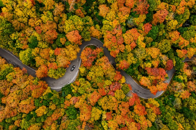
Smugglers’ Notch State Park
This is the defining stop for Route 108: a mountain notch with large boulders and a short walk. It suits travelers who want concentrated scenery rather than a long sequence of roadside views, and its listed crowd level is high with a typical visit length of one to two hours.
Access is the decision point. The notch road is narrow and seasonal and is unsuitable for large vehicles, so check closure status before driving. Use legal areas at the park, and note that a day-use fee may apply when facilities are operating.
AI-created illustrative image; not a documentary photographAnyMappy · AI-edited from a rights-cleared reviewed reference · AI-generated editorial imageImage source
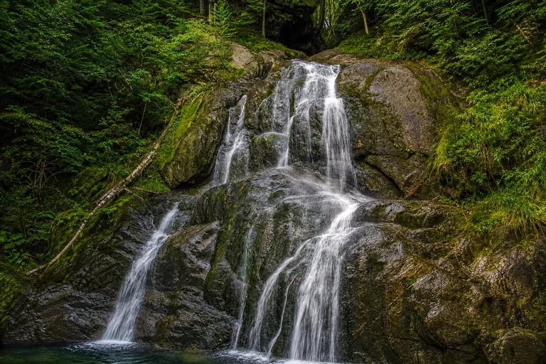
Moss Glen Falls
Moss Glen Falls gives a Route 100 foliage drive a precise, low-effort anchor: a roadside waterfall with a short boardwalk visit typically lasting 20 to 40 minutes. It works well for travelers who want a scenic stop without committing to a longer trail.
Use the signed pull-off and boardwalk, never the travel lane. No attraction admission is normally required, but current foliage timing still needs verification through Vermont’s live reports.
AI-created illustrative image; not a documentary photographAnyMappy · AI-edited from a rights-cleared reviewed reference · AI-generated editorial imageImage source
_2_(49437678742).jpg)
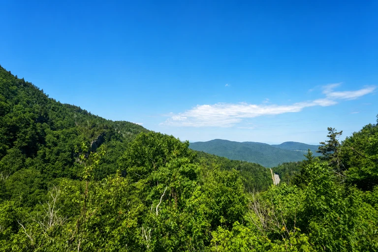
Appalachian Gap
Appalachian Gap is the focused scenic stop on Route 17, offering a mountain-pass overlook in a brief 15-to-30-minute visit. It suits drivers who want a high-road viewpoint and are comfortable with a steep, winding corridor.
Use designated pull-offs and avoid stopping on blind curves. The stop has no attraction admission, but the road’s geometry makes legal access and current road conditions more important than trying to extend the visit.
AI-created illustrative image; not a documentary photographAnyMappy · AI-edited from a rights-cleared reviewed reference · AI-generated editorial imageImage source

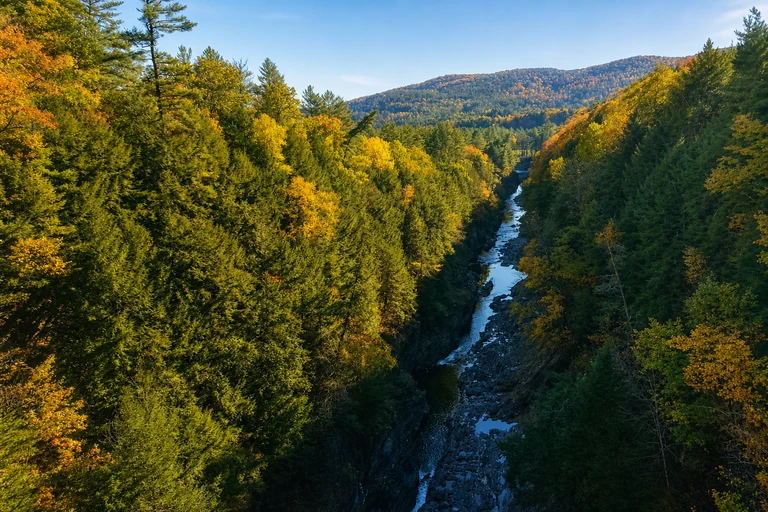
Quechee Gorge
Quechee Gorge is the high-visibility anchor for a US 4 foliage outing, with signed bridge walkways and a park trail leading to a longer view. Its typical visit lasts 45 to 90 minutes, making it a useful stop for travelers who want an accessible overlook with a family-friendly option.
Crowd pressure is high, so build parking and pedestrian movement into the plan. Stay behind barriers, and note that a state park day-use fee may apply for park facilities.
AI-created illustrative image; not a documentary photographAnyMappy · AI-edited from a rights-cleared reviewed reference · AI-generated editorial imageImage source
.jpg)
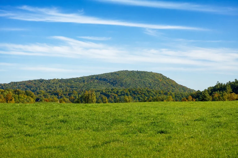
Mount Philo State Park
Mount Philo is the Champlain Valley choice for a summit road, lake view, and hike. It suits travelers who want a destination viewpoint rather than a purely roadside stop, with a typical visit of one to two hours.
The summit road is narrow and seasonal. Hiking remains an alternative when vehicle access is unavailable, and a state park day-use fee applies during the operating season.
AI-created illustrative image; not a documentary photographAnyMappy · AI-edited from a rights-cleared reviewed reference · AI-generated editorial imageImage source

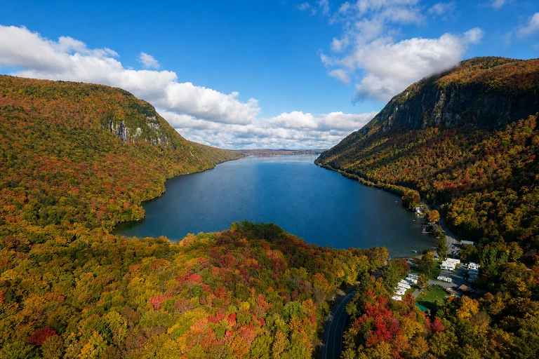
Lake Willoughby South Beach
Lake Willoughby South Beach anchors a Route 5A drive with lake-and-mountain scenery and a flexible 30-to-90-minute visit. It is a strong choice for travelers seeking a Northeast Kingdom landscape and an earlier northern planning window than Woodstock or Quechee.
Use designated beach and roadside parking. Cold-water and weather conditions can change quickly, and access rules vary by season and managed area, so check current notices before relying on the stop.
AI-created illustrative image; not a documentary photographAnyMappy · AI-edited from a rights-cleared reviewed reference · AI-generated editorial imageImage source

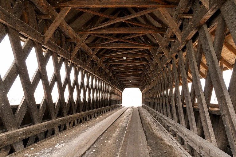
Middle Covered Bridge
The Middle Covered Bridge adds a walkable village stop to the US 4 and Woodstock corridor. It suits travelers who want historic character alongside fall scenery, with a typical visit of 30 to 60 minutes and high crowd pressure.
Park legally in town and explore on foot. The bridge remains part of a working street network, so it is not a place to stop or linger in the roadway. No attraction admission is required.
AI-created illustrative image; not a documentary photographAnyMappy · AI-edited from a rights-cleared reviewed reference · AI-generated editorial imageImage source

Marsh-Billings-Rockefeller National Historical Park
This Woodstock stop expands a foliage drive into a longer walking visit through a historic estate and managed forest, with carriage-road walks and a typical visit of 1.5 to 3 hours. It suits travelers who want more than a quick viewpoint and helps give the US 4 corridor a full-day shape.
Park at the signed visitor area and check NPS seasonal hours, tour availability, and trail alerts. Grounds and trails are generally free, while guided mansion tours may have separate reservation requirements.
AI-created illustrative image; not a documentary photographAnyMappy · AI-edited from a rights-cleared reviewed reference · AI-generated editorial imageImage source
.jpg)
What is the best scenic drive in Vermont for fall foliage?
There is no single best corridor for every traveler. Route 100 suits a focused mountain drive with Moss Glen Falls; Route 108 suits a notch and boulder walk; Route 5A suits Lake Willoughby’s lake-and-mountain scenery; and US 4 suits travelers who want Quechee Gorge and Woodstock in one regional plan.
Can I drive all of Vermont Route 100 in one day?
Route 100 is long, so the practical approach is to choose a segment rather than attempt the entire route in one day. Use Moss Glen Falls as an exact Route 100 stop and build the rest of the plan around nearby access and current conditions.
Is Vermont Route 108 through Smugglers’ Notch suitable for large vehicles?
No. The road through Smugglers’ Notch is narrow, seasonal, and unsuitable for large vehicles. Check closure status before driving and use only legal stopping areas.
Which Vermont foliage drive is better for an earlier planning window?
Lake Willoughby usually fits an earlier northern planning window than Woodstock or Quechee. The listed windows are historical planning ranges only; exact 2026 color timing is TBA until a live official report confirms conditions.
Where can I combine a scenic drive with a walkable Vermont town?
The US 4 and Woodstock corridor combines Quechee Gorge with Woodstock’s Middle Covered Bridge and Marsh-Billings-Rockefeller National Historical Park. Park legally in town for the covered bridge and check current national park hours, tour availability, and trail alerts.
What should I check before a Vermont fall foliage drive?
Check the official live foliage report, road status, seasonal closures, legal parking, park operating details, and access notices. These current sources override static route plans and historical color windows.